
Note: The content of this post is from answers to questions posed on Quora, written by Dylan Duverge. For the originally published content, Click Here.
This is a little anti-intuitive, but actually, numerous flash floods in deserts tend to reduce the depth of valleys. My answer is focused on the deserts of the American southwest, but is applicable to any desert consisting of a closed basin. A closed basin means any region where rain runoff collects in a terminal basin, never joining the ocean, either directly or through a river.
In the desert, streams are usually called “washes,” and with good reason. They are almost always dry, but when they aren’t, they are usually raging torrents of mud, i.e., they are experiencing a flash flood that basically washes out anything in its path. Go to pretty much any place in the southwest, and you’ll see a landscape similar to the image below.
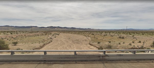
Looking at this image, you might think, “hey, look at those steep sandy banks, this wash really cuts into the landscape…I bet with enough flash floods, it will one day look like the Grand Canyon!” This makes sense superficially, but that is not actually how these desert basins work. As this landscape experiences multiple flash floods, the average elevation of the valley floor will increase.
To understand why, we must first understand how rocks, gravel, sand, silt and mud (collectively referred to as sediment) are 1) eroded, 2) moved and 3) deposited by water in a landscape. In essence, not all stream segments are alike, some will erode sediment in great quantities (erosion), some will deposit sediment (aggradation), and some will do a little of both (transport). Which one of these three categories a given stream segment belongs to depends on numerous factors, but the most important is the stream bed’s average slope. In general, streams with a high slope tend to erode sediment, and streams with a low slope tend to deposit sediment.
In the image below I’ve sketched the processes relevant to sediment erosion, transport and deposition. The red line is an elevation cross section, which distinguishes the mountain area from the valley area. What’s important here, is that sediment gets transported from the mountains to the valley. Over time, this raises the elevation of the valley. I’ve roughly sketched the streams in blue, which in the mountains are converging, and behaving “normally.” This is where sediment is picked up by storm runoff because of the high slope. However, as soon as the stream hits the valley, its behavior changes. It begins to diverge and split apart. This happens because the transition from high to low slope causes the water to slow down, which causes all of the heavy rocks, gravel and sand to drop out. This slowly builds up the land surface into what’s called an alluvial fan. In the image below, the layers I added in the elevation profile are packages of sediment that get deposited with repeated flash floods over long time periods.
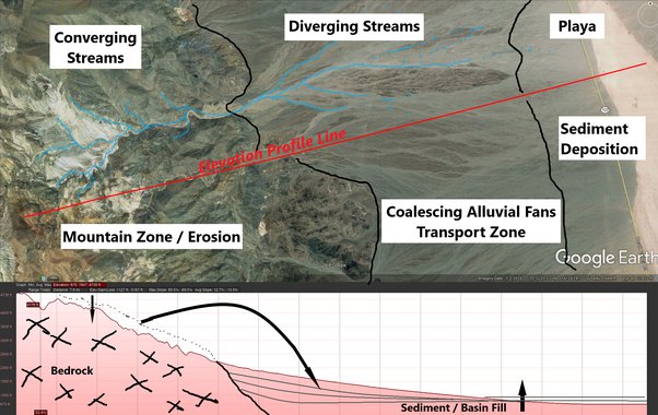
Although flash floods can locally carve washes, chasms, and/or canyons that are quite deep, the larger process at work is the transport of sediment from the mountains to the valleys. Yes, washes can have very deep banks, but it is because they are carving into layers of sediment deposited in prior flash floods. See how stream channels diverge in the image above? What is actually going on is lateral erosion. As land builds up, stream channels skip around because it is the stream banks that are being carved out, not the stream bottom. This is what causes the characteristic fan shape. Over time, sediment from the mountain source gets reshuffled and delivered closer to the terminal basin. Meanwhile, the average elevation of the valley floor increases because the eroded sediment has nowhere else to go.
Nature always wants to find a way to come to an equilibrium. So over geologic time, assuming no tectonic uplift, the elevation profile above will find a way to level out, reducing the elevation difference between the mountains and the valley floor.