

Note: The content of this post is from answers to questions posed on Quora, written by Dylan Duverge. For the originally published content, Click Here.
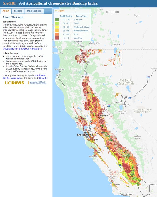
Desktop methods (i.e., GIS and remote sensing) for identifying ideal groundwater recharge zones are an excellent way to analyze very large areas quickly, though often you should expect to do some field confirmation/verification if you are going to proceed with a large scale recharge project. In simple terms, the soils should have a very large fraction of sand and gravel to allow for fast percolation of surface water, should be deep enough (i.e., without restrictive zones such as a hard-pan or shallow bedrock) to allow that percolation to reach the underlying aquifer, and should generally be flat or nearly flat lying. The image at the end of my answer is a map of California identifying ideal groundwater recharge zones in agricultural areas, prepared by researchers at UC Davis (follow the link to zoom in and read further). This is only one of many ways to do this, and is focused on existing agricultural lands, so it includes additional factors specific to agriculture. Specifically, these are[1]:
- Deep percolation: Soils must be readily able to transmit water beyond the root zone (1.5 m, 5 ft).
- Root zone residence time: The duration of saturated/near saturated conditions after water application must be acceptable for the crops grown on lands under consideration for groundwater banking throughout the entire crop root zone.
- Topography: Slopes that negatively influence the even distribution of water will be more difficult to manage.
- Chemical limitations: High soil salinity may result in saline leachate (poor water quality) that must be avoided to protect groundwater quality.
- Soil surface condition: Certain soils may be susceptible to compaction and erosion if large volumes of water are applied. Surface horizons with high sodium are prone to crusting that may contribute to decreased surface infiltration rates.
In my experience in the Western U.S, the best recharge areas tend to occur along alluvial fans that line the margins of large basins or valleys. Due to their proximity to the mountains, they tend to have a much larger percentage of gravel, cobbles, and sand than clay and/or silt. It’s when you get to the terminus of a basin that you start to get clayey soils. This is because the streams that exit the mountains experience a large drop in the stream gradient, and all the heavier grains drop out while all the lighter grains (silt and clay) remain in suspension and drop out toward the middle of the valley or basin. It is around the margins of the basin that most natural recharge occurs, so it makes sense to mimic this when contemplating artificial recharge.