Note: The content of this post is from answers to questions posed on Quora, written by Dylan Duverge. For the originally published content, Click Here.
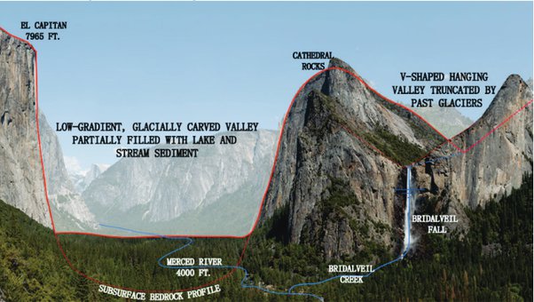
I first learned, in depth, about the differences between glacially-carved valleys and river valleys when I assisted Yosemite National Park in preparing the Merced Wild and Scenic River Comprehensive Management Plan in 2012. Pictured below is one of the most striking examples of a glacially-carved valley (Yosemite Valley) right alongside a river valley that the former glacier cut across, revealing its profile. This formed the famous Bridalveil Fall of Yosemite Valley. The textbook difference is the U-shape of a glacial valley versus the V-shape of a river valley. I’ll go into a bit more detail about why that is below.
Even though water and ice are both made of the same stuff (H2O), they act very differently upon the land for a number of reasons. It really comes down to the major differences in the magnitude, spatial extent, and temporal scale at which river systems operate versus glaciers. Glaciers, when present, are extensive, permanent, heavy and slow moving. They operate over geologic epochs associated with ice ages, such as what happened periodically in the Pleistocene epoch from 11,700 years ago way back to 2.6 million years ago. Rivers, in comparison, are narrow, variable in the rate and volume of their flow, and only episodically have enough “power” to significantly erode the soils and rock that underlie them (i.e., during high flows and/or floods).
The erosive power of rivers can only act over a narrow area at any one time, whereas river of ice are deep and broad, like the valleys they form. Rivers normally only have the power to move soil and sediment, even if they very slowly chip away at bedrock. Glaciers are akin to using your palm to sand plywood over and over. The bottom side of a glacier isn’t like a slick ice cube but more like the stuff on the side of the road left after a snow plow (not vanilla, but cookies ‘n cream).
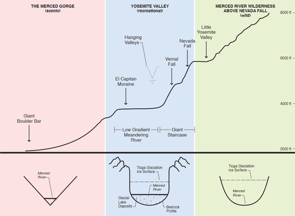
I love the diagram below[1] because it illustrates that the exact same river can form different valley shapes, based on it’s geologic history. The top part of the diagram is longitudinal profile of the Merced River, showing its elevation from its headwaters in the High Sierra (right hand side), to where it enters the SanJoaquin Valley Floor (left hand side). The part below shows a representative cross section (i.e., a cross-valley view) of each of these river segments. It shows how the upper reaches of the Merced River was influenced by glaciers in the geologic past, whereas the lower reach, untouched by glaciers, formed a deep V-shaped canyon.